Geospatial Assessment of Soil Erosion Dynamics and Hydrological Viability of the Gurrampalem Irrigation Tank, Visakhapatnam, using the RUSLE Model
DOI:
https://doi.org/10.5530/ctbp.2026.2.18Keywords:
RUSLE, Gurrampalem Reservoir, Visakhapatnam, Remote Sensing, Soil Erosion, Hydrological Viability, LULC DynamicsAbstract
The hydrological viability of minor irrigation tanks in the Eastern Ghats region of Andhra Pradesh is increasingly compromised by accelerated sedimentation and rapid land-use transitions. This study evaluates the soil erosion dynamics and storage sustainability of the Gurrampalem Reservoir in the Visakhapatnam district using an integrated Remote Sensing (RS), Geographic Information System (GIS), and Revised Universal Soil Loss Equation (RUSLE) framework. By leveraging high-resolution Sentinel- 2 (10m) multispectral imagery and ALOS PALSAR (12.5m) RTC-DEM data, the research quantifies the spatial distribution of soil loss across the catchment for the year 2025.
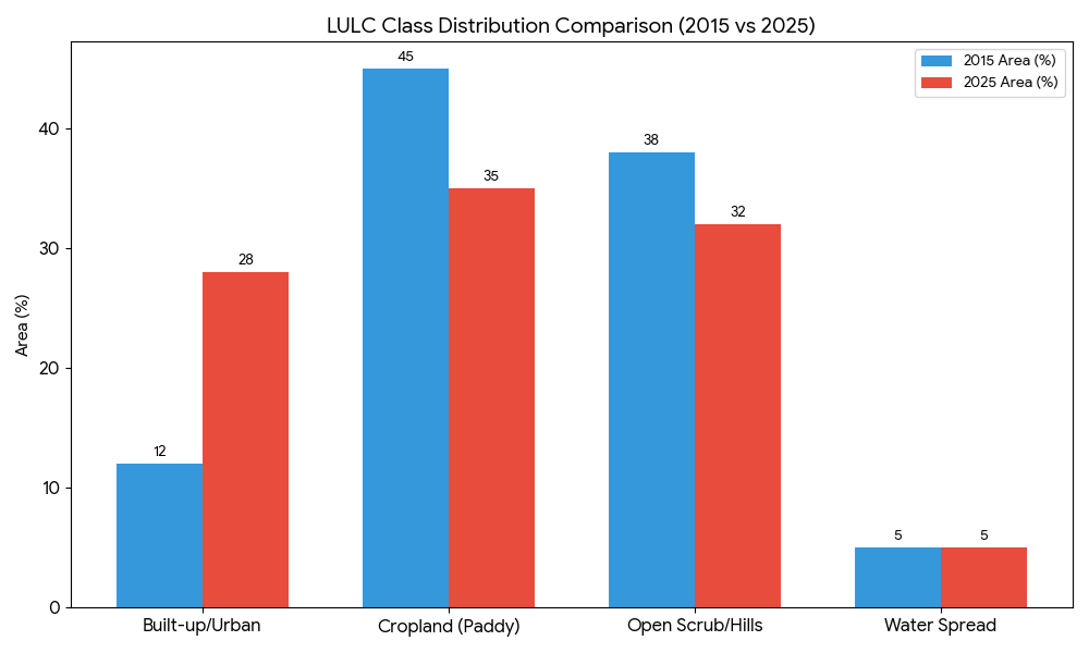
The methodology incorporates the Babu et al. Rainfall Erosivity (R) model and satellite- derived NDVI for cover management (C) mapping, specifically accounting for the recent surge in “real estate layouts” and stone quarrying activities in the Pendurthi corridor. Results indicate that the northern foothills of the Potukonda range represent severe erosion hotspots, with predicted soil loss exceeding 40 t/ha/yr due to steep LS-factors and depleted scrub cover. Furthermore, the analysis reveals that urban encroachment along the primary “Geddaps” (feeder channels) has triggered hydraulic scouring, significantly increasing the sediment delivery ratio (SDR) to the reservoir.
The study concludes that the cumulative impact of technogenic siltation from mining and the conversion of agricultural plains into barren residential plots has reduced the reservoir’s effective “Live Storage,” threatening its long-term viability for irrigation and groundwater recharge. These findings provide a scientific basis for prioritizing Catchment Area Treatment (CAT) plans and enforcing buffer zones to preserve the hydrological integrity of the Gurrampalem basin amidst Visakhapatnam’s expanding urban footprint.